|
|
|
|
|
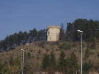
264 Kilometers to train yourself with 2000 meters of positive climb... |
|
264 Kilometers |
Number of visits : |
|
||
|
3 Cols |
|
|
|
|
||||||
|
|
|
|
||||||
|
|
|
|
||||||
|
|
|
|
||||||
|
|
|
|
||||||
|
|
|
|
||||||
|
|
|
|
|
|
|
|
|
|
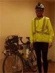
This ride will bring you around Vercors, but it is shorter than the other 300k ride also available on this link... You will ride around Vercors passing by Col de Grimone, a tiny road and a long descent will brings you in the Drome valley... I use to do this ride every year, in the beginning of the season to train. Follow this ride, all theses pictures have been taken at the end of March 2003 in order to train myself for the 300k PBP brevet.... |
|
|
|

|
|
|||||
|
|
|
||||
|
|
|||||
|
|
|||||
|
|
|
||||
|
|
|
|
|||
|
|
|
||||
|
|
|
|
|||
|
|
|
||||
|
|
|
|
|||
|
|
|
||||
|
|
|
||||
|
|
|||||
|
|
|||||
|
|
|
|
|||
|
|
|||||
|
|
|||||
|
|
|
||||
|
|
|
||||
|
|
|
||||
|
07:30am: The railway viaduct...
|
|
||||
|
|
|
||||
|
|
|
||||
|
|
|||||
|
|
|||||
|
|
||||
|
|
|
|
|||
|
|
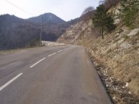
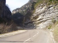
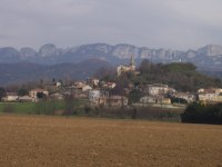
08:37am: An overview on mountains...
There are a lot of bends, and after each
of them, you discover another mountain...
|
||||
|
|
|
|
|||
|
|
|
|
|||
|
|
|||||
|
|
|||||
|
|
|
|
|||
|
|
|
|
|||
|
|
|||||
|
|
|||||
|
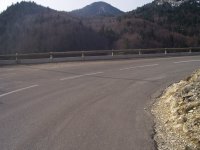
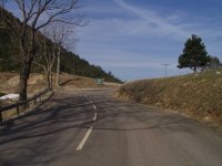
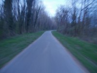
09:00am: Leaving the main road N75....
Here is the beginning of the climb towards
Col de Grimone. This road is not a main road, but a tiny road...
|
|
||||
|
|
|
||||
|
|
|
||||
|
|
|
|
|||
|
|
|
||||
|
|
|
|
|||
|
|
|
||||
|
|
09:10am: The second milestone...
Still pedaling during 2,4 kilometers...
|
|
|||
|
|
|
||||
|
|
|
||||
|
|
|
|
|||
|
|
|
||||
|
|
|
|
|||
|
|
|
||||
|
|
|
||||
|
|
|
||||
|
|
|
||||
|
|
|
||||
|
|
||||
|
|
|
|
|||
|
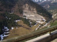
09:20am: The fourth milestone....
You are close to the top now...
|
|
||||
|
|
|
||||
|
|
|
|
|||
|
|
|
||||
|
|
|||||
|
|
|||||
|
|
|
|
|||
|
|
|
||||
|
|
|
|
|||
|
|
|
||||
|
|
||||
|
|
|||||
|
|
|||||
|
|
|
|
|||
|
|
|
||||
|
|
|||||
|
|
|||||
|
|
|
|
|||
|
|
|||||
|
|
|||||
|
|
|
|
|||
|
|
|
||||
|
|||||
|
|
|
|
|||
|
|
|||||
|
|
|||||
|
|
|
||||
|
|
|||||
|
|
|||||
|
|
|
|
|||
|
|
|
||||
|
|
|||||
|
|
|||||
|
|
|
||||
|
|
|||||
|
|
|||||
|
|
|
|
|||
|
|
|||||
|
|
|||||
|
|
|
||||
|
|
|
|
|||
|
|
|||||
|
|
|||||
|
|
|
|
|||
|
|
|||||
|
|
|||||
|
|
|
|
|||
|
|
|
|
|||


| THE ROADMAP DETAILLED... | |
| Road | Hour | Dept | Ville | Altitude | Km Part | Km Total | Average |
| 04:35am | 38 | Grenoble | 200 | 0 | 0 | ||
| Rue Ampere - Bachelard | 200 | 3 | 3 | ||||
| Echirolles | 200 | 1 | 4 | ||||
| N75 | Claix | 200 | 4 | 8 | |||
| N75 | Varces | 240 | 4 | 12 | |||
| N75 | 05:25am | Vif | 311 | 5 | 17 | 21,5 | |
| N75 | 06:00am | Carrefour A51 | 8 | 25 | |||
| N75 | 06:35am | Monestier de Clermont | 840 | 8 | 33 | ||
| N75 | 06:45am | Col du Fau | 899 | 2 | 35 | 16,7 | |
| N75 | 834 | 4 | 39 | ||||
| N75 | 836 | 1 | 40 | ||||
| 829 | 1,5 | 41,5 | |||||
| 844 | 1,5 | 43 | |||||
| N75 | 07:25am | Viaduc SNCF | 810 | 3 | 46 | 18,5 | |
| 770 | 0,5 | 46,5 | |||||
| N75 | 07:30am | Carrefour D7 (Le Chaffaud) | 830 | 2,5 | 49 | ||
| N75 | 07:50am | Carrefour Le Percy (pont) | 842 | 5 | 54 | 18,6 | |
| N75 | 870 | 6 | 60 | ||||
| N75 | 08:15am | Le Chalet | 870 | 1 | 61 | 18,9 | |
| N75 | Carrefour vers Lalley | 920 | 1 | 62 | |||
| N75 | 08:45am | 38 | Col de la Croix Haute | 1179 | 5 | 67 | 17,9 |
| N75 | 08:55am | 26 | Carrefour D539 à droite | 1068 | 3 | 70 | |
| D539 | 1098 | 0,3 | 70,3 | ||||
| D539 | 1158 | 0,7 | 71 | ||||
| D539 | 1219 | 1 | 72 | ||||
| D539 | 1274 | 1 | 73 | ||||
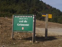
| D539 | 09:25am | Col de Grimone | 1318 | 4 | 74 | 17,5 | |
| D539 | 1280 | 1 | 75 | ||||
| D539 | 1223 | 1 | 76 | ||||
| D539 | 1167 | 1 | 77 | ||||
| D539 | 09:45am | Grimone | 1113 | 1 | 78 | 17,9 | |
| D539 | 1059 | 2 | 79 | ||||
| D539 | 1000 | 1 | 80 | ||||
| D539 | 935 | 1 | 81 | ||||
| D539 | 894 | 1 | 82 | ||||
| D539 | 10:00am | Glandage | 855 | 1 | 83 | 18,2 | |
| D539 | 10:35am | Chatillon en Diois | 500 | 13 | 96 | 19,1 | |
| D539 | 11:00am | Saint Roman | 480 | 6 | 101 | ||
| D539 | 11:05am | Pont de Quart | 440 | 3 | 104 | 19,5 | |
| D93 | 11:30am | Die | 400 | 6 | 110 | 19,7 | |
| D93 | 610 | 8 | 118 | ||||
| D93 | 12:00am | Pontaix | 330 | 3 | 121 | 20 | |
| D93 | 12:35am | Vercheny | 320 | 5 | 126 | 20,2 | |
| D93 | Espenel | ||||||
| D93 | 01:00pm | Saillans | 260 | 6 | 132 | 20,2 | |
| D93 | 01:30pm | Mirabel et Blacons | 218 | 9 | 141 | ||
| D93 | 01:35pm | Aouste sur Sye | 200 | 3 | 144 | 20,3 | |
| D93 | 01:45pm | Crest | 180 | 3 | 147 | 20,4 | |
| D538 | 276 | 8 | 155 | ||||
| D538 | 02:50pm | Chabeuil | 200 | 21 | 168 | ||
| D68 | 03:20pm | Carrefour D125 à gauche | 200 | 3 | 171 | ||
| D125 | 298 | 5 | 176 | ||||
| D125 | 03:40pm | Charpey | 278 | 1 | 177 | 20,7 | |
| D125 | 400 | 5 | 182 | ||||
| D125 | 04:00pm | Rochefort Sansom | 374 | 1 | 183 | 20,7 | |
| D125 | 394 | 1 | 184 | ||||
| D125 | La Combe d'Oyans | 370 | 1 | 185 | |||
| D125 | 400 | 1 | 186 | ||||
| D125 | 411 | 2 | 188 | ||||
| D125 | Carrefour vers Beauregard Baret | 433 | 1 | 189 | |||
| D125 | 04:20pm | Hostun | 231 | 4 | 193 | 20,9 | |
| D125 | Carrefour N532 | 197 | 4 | 197 | |||
| N532 | 04:35pm | Carrefour D76 | 188 | 1 | 198 | 21,1 | |
| N532 | 38 | 196 | 1 | 199 | |||
| N532 | 04:50pm | Saint Just de Claix | 208 | 3 | 202 | ||
| D71A | 201 | 4 | 206 | ||||
| D71 | 05:05pm | La Sone | 188 | 1 | 207 | ||
| D71 | Carrefour N92 | 260 | 2 | 209 | 21 | ||
| N92 | 05:30pm | Saint Marcellin | 270 | 4 | 213 | 21 | |
| N92 | Saint Sauveur | 260 | 1 | 214 | |||
| N92 | Beaulieu | 230 | 7 | 221 | |||
| N92 | 06:05pm | Vinay | 240 | 2 | 223 | 21,2 | |
| N92 | L'Allegrerie | 235 | 2 | 225 | |||
| N92 | L'Albenc | 230 | 1 | 226 | |||
| N92 | Carrefour Chantesse | 270 | 2 | 228 | |||
| N92 | 230 | 2 | 230 | ||||
| N92 | 06:25pm | Carrefour D201 | 270 | 5 | 231 | ||
| N92 | Tullins | 230 | 5 | 236 | |||
| D45 | 06:50pm | Carrefour PC | 200 | 4 | 240 | 21,3 | |
| PC | 08:00pm | Grenoble | 200 | 24 | 264 | 21,4 |
|
|
|
|

|
|
|
|
Your feedbacks will be welcomed... |
||||||
|
Page ridden at the end of March 2003 and written in April 2003 by Jean-Philippe BATTU... |
|||||||