|
|
A GREAT RIDE AROUND "VERCORS" INCLUDING AN ESCAPADE IN "DIOIS" |
|
|
300 Kilometers around Grenoble to train yourself... |
|
300 Kilometers |
Number of visits : |
|
||
|
4 Cols |
|
|
|
|
||||||
|
|
|
|
||||||
|
|
|
|
||||||
|
|
|
|
|
|
|
|
|
|
|
|
|
|
This ride takes place in French Alps around "Vercors" and "Diois" mountains. It is 300 kilometers long with a little incursion into "Diois". I strongly recommend this ride if you need to train yourself for long rides such as Bordeaux-Paris or Paris-Brest-Paris 2003 (PBP 2003). I do this ride every year, at the beginning of the cycling season, it is a good way to find again the pleasure of the long distance cycling. Follow this ride on the map, enjoy the photos and take your bike to do the same... |
|
|
|

|
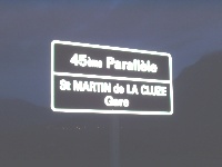
I start from "Grenoble" at 05h00am. It is still the night. I cross the city center using my lights and after "Vif", I join the 45th parallel at the end of the night... |
|
|||||||
|
|
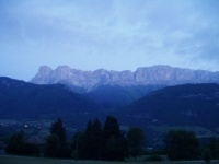
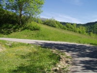
Theses two pictures show you the main road (N75) and the Vercors seen here at sunrise... The road climbs a little during the first 30 kilometers... |
|
||||||
|
06:15am: Here is the first village on this main road: "Le Monestier de Clermont". There is a big climb at the end of this village, but not too long... |
|
|||||||
|
|
||||||||
|
|
||||||||
|
|
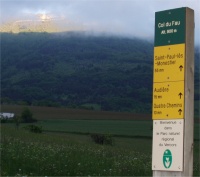
This (hard) climb brings you to the first Col of this ride: "Col du Fau" between "Vercors" and "Trieves"... |
|
||||||
|
|
||||||||
|
The main road follows an old railway, but still in use! Here is an old train which goes from Gap to Grenoble passing by "Col de la Croix Haute". This railway is very old, it has been built in 1878. It goes through 6 tunnels with 23 kilometers of climb... |
|
|||||||
|
|
Between "Col du Fau" and "Col de la Croix Haute", the road is a little hilly with short climbs and short descents. When you will see this pannel, it will be the beginning of the climb to the Col... |
|||||||
|
At 08:00am, the road climbs gently... |
|
|||||||
|
|
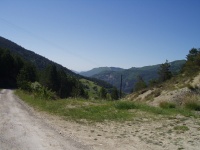
On your left, you discover the nice countryside on "Trieves"... The village down under is called "Lalley"... |
|||||||
|
This morning, the weather is cloudy. In "Col de la Croix Haute", the weather often changes. Perhaps, do you notice the blue sky at the end of the road.... |
|
|||||||
|
|
Yes, more and more, the climb brings you to the sun... |
|||||||
|
|
You will have time to enjoy short bends... |
|
||||||
|
|
||||||||
|
|
||||||||
|
|
When you see this bridge, with the railway over your head, you are close to the top. The "Col de la Croix Haute" is here, on your right... |
|
||||||
|
|
At "Col de la Croix Haute", we leave Isere department to enter in "Drome"... Be careful with the railway, you are going to cross it another time in the descent... |
|
||||||
|
Saint Julien de Beauchène... |
|
...Cows are here... |
||||||
|
|
||||||||
|
|
||||||||
|
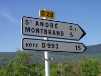
We leave the main road (N75) in "La Faurie". On your right, follow the little road marked as D28. Before joining D993, you will pass another Col... Are you ready ? |
|
|||||||
|
|
First we cross a little village (two houses)... |
|||||||
|
The road is flat and you have to enjoy this green countryside... |
|
|||||||
|
|
Suddendly, the climb begins in the forest... |
|||||||
|
|
A hard bend to show you the climb... |
|
||||||
|
The road becomes narrow, we arrive in "Creyes"... |
|
|||||||
|
|
The climbs continues... |
|||||||
|
If you have a look behind you, you notice a nice point of view... |
|
|||||||
|
|
No doubt! the road is enjoyable... |
|
||||||
|
|
...and the climb not too difficult, you are close to the top... |
|
||||||
|
|
Go honking on the bike to finish the climb. Here is "Col de la Haute Beaume". It is the highest point of this ride... |
|
||||||
|
|
Here is an overview on the descent... |
|
||||||
|
|
||||||||
|
|
In the descent, take your time to gaze at the countryside... |
|||||||
|
This picture has been taken further in the descent. We can see the main road coming from "Aspres sur Buesch" and climbing to "Col de Cabre". We are going to join this road on the next image... |
|
|||||||
|
|
||||||||
|
|
||||||||
|
|
Here is the intersection with this main road. After a steep descent, here is now another climb to "Col de Cabre". Hurry up, it is half past ten... |
|||||||
|
|
This road is quiet, not a boring road... |
|
||||||
|
Here is a point of view on my handlebar. My cycle computer shows 10km/h in this climb, not too difficult... |
|
|||||||
|
|
The climb continues, we can't see the top... |
|
||||||
|
|
...but when you see this house, you are close to the top... |
|||||||
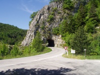
|
Here is "Col de Cabre"... |
|
|||||||
|
|
...At the col, you have to be careful ! Yes there is a big lime. I hope you are not allergic to this kind of pollen, I blew my nose... |
|
||||||
|
|
Now it is the descent. Are you ready to ride thirty bends with nine hairpin bends ? |
|||||||
|
You enjoy "Vercors" during the descent in your right... |
|
|||||||
|
|
||||||||
|
|
||||||||
|
|
After "Beaurières", the road follows "Drome" river and you arrive to the "Claps"... |
|
||||||
|
In 1480, there was a landslip and... |
|
|||||||
|
|
...and the river has been modified... |
|||||||
|
|
This place is enjoyable, perhaps have you already ridden here ? |
|
||||||
|
|
At Midday, I arrive in "Luc en Diois"... |
|||||||
|
|
||||||||
|
|
||||||||
|
During the descent, I get the wind in my nose. It is not the first time I notice this wind which brings the cyclist towards "Col de Cabre". Hovewer, here is "Die" with its tower called "Tour du Purgnon"... |
|
|||||||
|
|
Further, in Drome valley, you notice "Pontaix" with its church and the old castle... |
|
||||||
|
|
On your left, here is the river. Enjoy this ride with the "Vercors" located on your right... |
|||||||
|
|
||||||||
|
|
||||||||
|
|
After 184kms, here is "Crest". This place is well known because "La Semaine Federale" took place in 2001 and there is the highest tower in France, seen here on the right... |
|
||||||
|
|
||||||||
|
|
||||||||
|
|
At 05:00pm, the weather is always fine. Here is "Chabeuil" with an overview on the church... |
|
||||||
|
|
...and the town hall of "Chabeuil"... |
|||||||
|
|
The ride continues in a quiet road to avoid "Romans sur Isere". Yes, there are little hills, but I prefer hills rather boring roads !... "Vercors" is still on your right... |
|
||||||
|
|
When you see this place, you will be ready to ride a decent descent towards Isere valley... |
|||||||
|
|
||||||||
|
|
||||||||
|
In this descent, take your time to have a look on "Beauregard-Baret" with "Vercors" on the background... |
|
|||||||
|
|
After 230kms, I arrive in "Hostun"... |
|||||||
|
|
"Isere" river is large and peaceful here. The sunset is coming, the ride continues towards "Saint Hilaire du Rosier" where Kirsch is manufactured... |
|
||||||
|
|
||||||||
|
|
||||||||
|
After "Saint Marcellin" I arrive in "Vinay"... |
|
|||||||
|
|
||||||||
|
|
||||||||
|
|
After "Tullins", the sun still illuminates "Vercors"... |
|||||||
|
|
After 274kms, I join the bicycle lane with nobody. It is late in the evening and I arrive in "Grenoble" one hour later... |
|
||||||
|
So, with 300 kilometers and approximately 2000 meters of total positive climb, this climb is enjoyable for the countryside and your training to do long rides. If you want to do Paris Brest Paris 2003 (PBP 2003), I strongly recommend this ride, take your bike, happy pedaling... |
||||||||
|
|
||||||||


| THE DETAILLED ROUTE MAP... | |
| Route | Time | Town | Altitude | Km Part | Km Total |
Average |
| 04:05am | Grenoble | 200 | 0 | 0 | ||
| Echirolles | 200 | 6 | 6 | |||
| N85 | Pont de Claix | 200 | 3 | 9 | ||
| N85 | Varces | 200 | 4 | 13 | ||
| N75 | 04:50am | Vif | 311 | 3 | 16 | 23,4 |
| N75 | 06:10am | Monestier de Clermont | 810 | 17 | 33 | |
| N75 | 06:20am | Col du Fau | 899 | 2 | 35 | 17,5 |
| N75 | Le Chaffaud | 830 | 13 | 48 | ||
| N75 | Les Combes | 824 | 8 | 56 | ||
| N75 | Le Chalet | 879 | 5 | 61 | ||
| N75 | La Chapelle | 910 | 1 | 62 | ||
| N75 | Monument de Gayvallet | 1135 | 3 | 65 | ||
| N75 | 08:20am | Col de la Croix Haute | 1179 | 6 | 66 | 18,5 |
| N75 | 940 | 10 | 76 | |||
| N75 | Pont sur le Buech | 930 | 1 | 77 | ||
| N75 | Saint Julien en Beauchène | 920 | 3 | 80 | ||
| N75 | Pont sur la Pochette | 900 | 3 | 83 | ||
| N75 | 09:10am | La Faurie | 850 | 3 | 86 | 20,5 |
| D28 | Saint André | 855 | 1 | 87 | ||
| D28 | Montbrand | 870 | 5 | 92 | 20,2 | |
| D28 | Ruynet | 930 | 1 | 93 | ||
| D28 | Creyes | 990 | 1 | 94 | ||
| D28 | 10:20am | Col de la Haute Beaume | 1268 | 4 | 98 | 19,3 |
| D28 | Carrefour D993 | 1000 | 3 | 101 | ||
| D993 | 10:55am | Col de Cabre | 1180 | 3 | 104 | 18,9 |
| D93 | 1160 | 1 | 105 | |||
| D93 | 1120 | 1 | 106 | |||
| D93 | 1080 | 1 | 107 | |||
| D93 | 1040 | 1 | 108 | |||
| D93 | 980 | 1 | 109 | |||
| D93 | 940 | 1 | 110 | |||
| D93 | 890 | 1 | 111 | |||
| D93 | 850 | 1 | 112 | |||
| D93 | 800 | 1 | 113 | |||
| D93 | 11:20am | Beaurières | 765 | 1 | 114 | |
| D93 | Carrefour D306 à gauche | 750 | 3 | 117 | ||
| D93 | Les Rosières | 630 | 8 | 125 | ||
| D93 | Le Claps | 580 | 2 | 127 | ||
| D93 | 12:15am | Luc en Diois | 561 | 2 | 129 | |
| D93 | Montlaur en Diois | 480 | 2 | 131 | ||
| D93 | Recoubeau | 430 | 3 | 134 | ||
| D93 | 12:40am | Pont de Quart | 420 | 7 | 141 | 20,5 |
| D93 | 01:20pm | Die | 400 | 6 | 147 | |
| D93 | 12:00pm | Pontaix | 350 | 10 | 157 | |
| D93 | Vercheny | 330 | 6 | 163 | ||
| D93 | Pont d'Espenel | 310 | 2 | 165 | 20,8 | |
| D93 | 02:35pm | Saillans | 300 | 4 | 169 | |
| D93 | 03:00pm | Mirabel et Blacons | 260 | 9 | 178 | 20,9 |
| D93 | Aouste sur Sye | 250 | 3 | 181 | ||
| D93 | 03:45pm | Crest | 200 | 3 | 184 | 21 |
| D538 | 260 | 5 | 189 | |||
| D538 | 05:00pm | Chabeuil | 212 | 16 | 205 | 20,7 |
| D125 | 05:50pm | Charpey | 250 | 8 | 213 | |
| D125 | Barbières | 280 | 4 | 217 | ||
| D125 | 06:10pm | Rochefort Sanson | 230 | 3 | 220 | |
| D125 | 06:30pm | Beauregard-Baret | 260 | 6 | 226 | |
| D125 | Hostun | 210 | 3 | 229 | ||
| D125 | Carrefour N532 à droite | 160 | 4 | 233 | ||
| N532 | Carrefour D76 à gauche | 160 | 1 | 234 | ||
| D21 | 07:10pm | Saint Hilaire du Rosier | 220 | 4 | 238 | |
| N92 | 07:40pm | Saint Marcellin | 230 | 8 | 246 | |
| N92 | Vinay | 210 | 10 | 256 | ||
| N92 | L'Albenc | 230 | 4 | 260 | ||
| N92 | Carrefour D201 | 250 | 9 | 264 | ||
| N92 | Tullins | 230 | 5 | 269 | ||
| D45 | 09:00pm | Carrefour PC | 200 | 5 | 274 | |
| PC | 10:00pm | Grenoble | 200 | 23 | 297 | 20,3 |
|
|
|
|
|
|
|
|

|
|
Your feedbacks are welcome... |
||||||
|
|||||||