|
||||||||
|
||||||||
|
We are in Chartreuse, not very far from Grenoble (about 28 miles) to discover "Col de la Charmette". It is located on a very small road, closed to cars and forbidden to any traffic. Due to this, snow disappears later (June) and appears just after Autumn season and the road service is very bad. It is a cold and windy place where you will be able to see ibex... The road is smashed in the north side from Saint Laurent du Pont. I advice to climb from this side to see large holes in the road. You will need lights on your bike to go through tunnels without difficulties... Here is a map of this ride: |
||||||||
|
|
||||||||
|
You will start from Saint Laurent du Pont at 430 meters of altitude... This is the church in Saint Laurent du Pont... |
||||||||
|
|
||||||||
|
In the main crossroad, take the road to Saint Pierre de Chartreuse by "Gorges du Guiers". Perhaps you will recognize this place: |
||||||||
|
|
||||||||
|
Just after the village, take the tiny road on your right. You won't be able to miss this road if you want to ride a good climb! This place is marked with a purple circle on the previous road map... |
||||||||
|
|
||||||||
|
As we can see, there are plenty of holes in the road. A good climb to begin and have a look to your cycle computer: Your average speed is going to slow down! If you have a triple, this climb is for you. If not, perhaps do you prefer to walk besides your bike ? So, are you ready for 10 kilometers of climbing ? |
||||||||
|
|
||||||||
|
In the climb, your speed will allow you to discover waterfalls and forest pannels... |
||||||||
|
|
||||||||
|
The first kilometers are terrible ! No flat moments to recover ! The road becomes more and more tiny... Where are we going to go ? |
||||||||
|
|
||||||||
|
Later, nature is the chief in this place... No cars... |
||||||||
|
|
||||||||
|
If you are concentred by the climb, please think I stopped many times with the bike to do photos for your pleasure... You are 30 kms far from Grenoble... |
||||||||
|
|
||||||||
|
Later the road is drawn into the rock. This place is fabulous... |
||||||||
|
|
||||||||
|
The first tunnel appears: It is called: "Tunnel du Sourd"... |
||||||||
|
|
||||||||
|
Seven kilometers after exiting Saint Laurent du Pont, we arrive near a monastery called: "Monastery de Curière"... |
||||||||
|
|
||||||||
|
This place is the only one house in this climb... |
||||||||
|
|
||||||||
|
The road continues to climb near the rock. If you notice, I rode this climb twice with my camera. One was just after wintertime (no leafs on the trees) and the second one with Isabelle, in Summertime... |
||||||||
|
|
||||||||
|
One kilometer later, we arrive in "Parking des Agneaux". The road is forbidden to cars and you risk a penalty. You will be prosecuted if you continue. I advice you to stop here. Enjoy only photos... |
||||||||
|
|
||||||||
|
This car park is located at 850 meters of altitude. We still must complete 500 meters of positive climb. You are ready to continue, because the descent towards Saint Laurent du Pont is too dangerous... |
||||||||
|
|
||||||||
|
During this climb, you will enjoy forest panels to present you animals and flowers... As Paul McCartney said, it is not "flowers in the dirt" but "flowers in the climb"... |
||||||||
|
|
||||||||
|
The second tunnel arrives. You need switch lights on to go through. It is called "Tunnel des Agneaux"... |
||||||||
|
|
||||||||
|
Here is another tunnel with a cyclist... |
||||||||
|
|
||||||||
|
The climb becomes human now... |
||||||||
|
|
||||||||
|
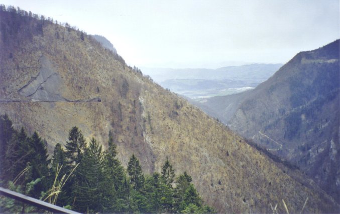
Suddendly, on the left, the seesight is fabulous... "Gorges du Guiers" under your eyes... |
||||||||
|
|
||||||||
|
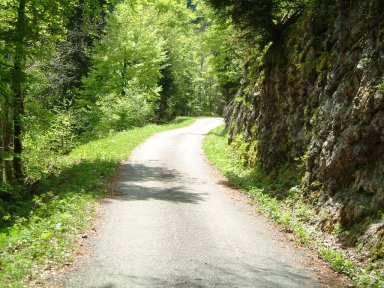
Be careful later with this tiny road. Mountain on your right, nothing on your left... |
||||||||
|
|
||||||||
|
The last tunnel is very nice but very old... Perhaps an old passage in the mountain ? |
||||||||
|
|
||||||||
|
One hour AND a half after exiting Saint Laurent du Pont, the road continues to climb in the forest. But the climb is going to finish. Perhaps you feel fresh air aroud your neck... In June, I got snow here and had to descent by Saint Laurent du Pont again... After this pannels, cars will be allowed again on this road... |
||||||||
|
|
||||||||
|
We are arrived in Col de la Charmette. On the right, the forest house... |
||||||||
|
|
||||||||
|
And the monument at the top... |
||||||||
|
|
||||||||
|
Here, many beautiful seesight towards "Charmant Son" and forest pannels... |
||||||||
|
|
||||||||
|
The final pannel presents you the current altitude... |
||||||||
|
|
||||||||
|
"Col de la Charmette" is very quiet. You may walk in the mountain from this point. |
||||||||
|
|
||||||||
|
After the climb, it is time to descent. The road will be better now and you will follow the little river, on you right, called "La Tenaisson"... |
||||||||
|
|
||||||||
|
In the descent, don't go too fast. From this place, you will be able to see Vercors mountains... |
||||||||
|
|
||||||||
|
After the descent in the forest with some bends, you will arrive in "Pomarey", just over "Quai en Chartreuse"... |
||||||||
|
|
||||||||
|
I hope you will enjoyed this ride in an unknown col near Grenoble. With this ride, you crossed Chartreuse from the North to the South. Congratulations ! |
||||||||
|
|
||||||||